
Property Hunting on the Canal entre Champagne et Bourgogne, (North)
Let's explore the northern half of the Canal entre Champagne et Bourgogne, and check out the property options in settlements along its route.
The Canal entre Champagne et Bourgogne was previously known as the Canal de la Marne à la Saône. Commercial boatmen also know the canal as the Heuilley. Building the canal began in 1862, but progress was slow, and the canal was not completed until 1907. Only seven years later, France was at war with Germany. The area around the northern reaches of the canal was much affected by the events of both the First and Second World Wars, and you will find a variety of war memorials, Commonwealth War Grave Commission graves for British soldiers, and other military sites of interest along the route.
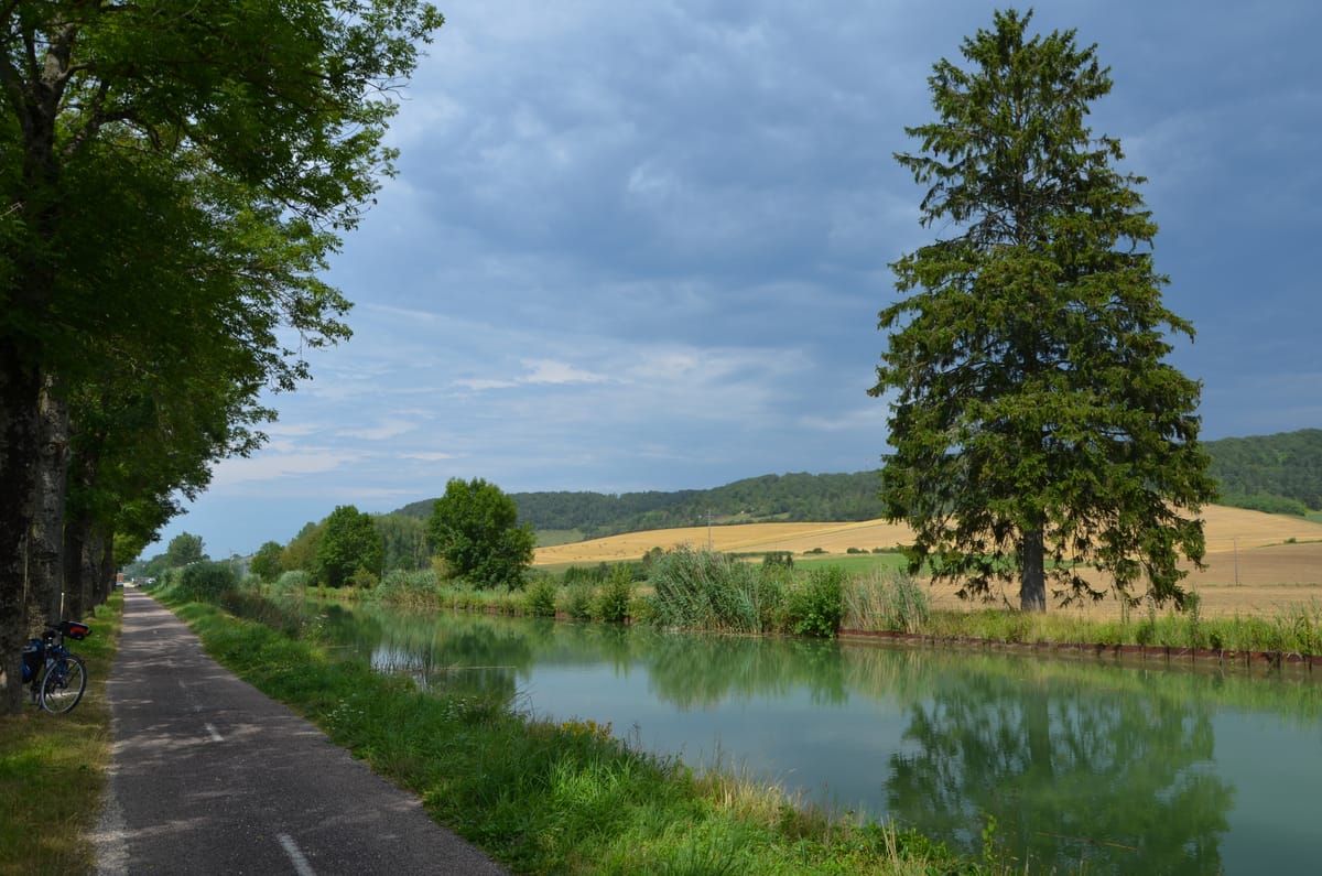
The canal begins at Vitry-le-François, where it connects with the Canal de la Marne au Rhin. It crosses the Langres plateau then drops down through the Vingeanne valley and connects with the upper reaches of the River Saône at Heuilley-sur-Saône. The canal is 224 km long in total, and there are 71 locks between Vitry and Langres. The landscape begins flat and fairly featureless, gradually introducing rolling hills and woodland, and generally becoming wilder and more remote the further south we go. There are only a handful of large settlements; most of the villages and hamlets are tiny, without shops or facilities.
In this post I will cover the northern half of the canal, from Vitry-le-François to Viéville, in the countryside just north of the city of Chaumont, with its population of 21,699, or the section south of Chaumont, including the 43 locks between Langres and Maxilly and the 5km long tunnel at Balesmes.
Vitry-le-François

We begin our journey at Vitry-le-François, which had a population of 11,454 in 2021. There is an impressive town square, le Place d'Armes, and a 17th-century church, and of course, many shops and facilities. I'd love to find out more about its role in WW1. Seven British soldiers are buried in the cemetery. The town was at the epicentre of the fighting during the first Battle of the Marne, then after the French victory, it became an important relief centre, and its hospitals treated well over 2,000 wounded soldiers. There's a great painting in the Imperial War Museum of a canteen for French and British troops.

Most of the housing is modern, because much of the town was burned and bombed in WW2. You'll find plenty of pavillon style properties, red brick dormer bungalows, and some blocks of apartments. However, there are are some pleasant residential areas near the waterway, and some of the houses have fantastic views over the péniches (commercial barges) moored along the canal.
There is a large pleasure basin in the town, and Lock 71, the Désert, is in the town centre. We exit the town to the south east, and at Lock 70 we pass to the north of a suburb, Frignicourt. Now we emerge into lush open farmland. The landscape around here is quite flat, and there isn't much in the way of scenery to attract second home owners. The first village we pass, Luxémont-et-Villotte, gives its name to the first lock, Lock 69. The village is a good long stroll away from the canal. It is well tended but unremarkable. The land is still quite flat, and the canal passes numerous wide fishing lakes before arriving at Lock 66 on the outskirts of Orconte, a fairly dull little village. The lakes and locks continue until we reach Lock 63, with the plain working village of Perthes to the north of the canal and its suburb, Sapignicourt, to the south.
Hallignicourt
Continuing east we reach the unusual hamlet of Hallignicourt, with its remarkably large village square, the Place de la Mairie, with a war memorial in the centre of the square. The main RN4 road runs parallel to the canal here. There used to be a disused restaurant here, called La Bobotte, but it was destroyed in a fire in 2018. There's a curious little memorial to the south of the canal just past the bridge. I wonder what it is for?
Saint Dizier
Past Lock 60, the de Hoericourt Lock, the canal and the RN4 enter the large town of Saint Dizier side by side. There is plenty here to interest military historians. In 1921, the government awarded the city the Croix de Guerre in recognition of its role during WW1, as a hub for food and ammunition supply, and as a base for troop movements towards Argonne, Verdun, and the East. The war memorial a short walk from the canal is a humbling sight. It was built in 1923 and commemorates over 700 soldiers who died in WW1. The angel was damaged during a storm in 2021, but it has since been restored.
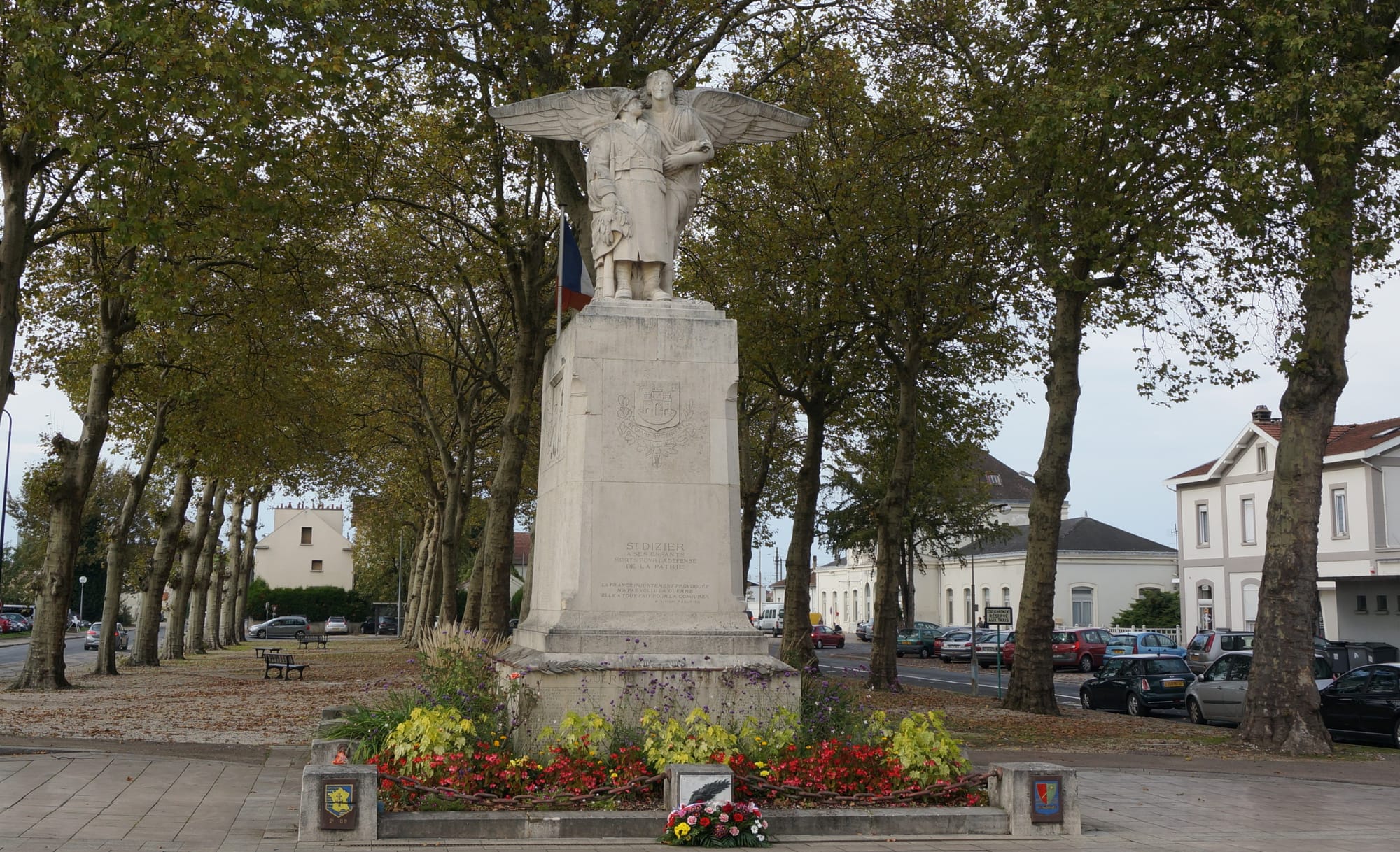
Ther was a very different story in WW2. The town was seized by the Germans in June 1940 during the Battle of France, and the airfield was used as a Luftwaffe military airfield during the occupation.
Today Saint Dizier haw a population of around 23,000. It has a attractive town centre - it is remarkable that many old buildings have survived both world wars, and I have to congratulate the town planners on their efforts to contain rebuilding. Surprisingly the canal is not entirely dominated by industry, and there are several streets of residential houses directly overlooking the canal.

Just before we exit the town, the railway comes alongside the canal. After passing under the RN4, the scenery changes, and we return to the countryside. We leave the railway behind and follow the valley of the River Marne.
Chamouilley
Before too long the canal enters the village of Chamouilley. There is a motorhome site, and plenty of green space to enjoy by the canal. The village itself is quite suburban in style, and not remarkable, but it has a mix of old and new, and some useful services and shops. We head out of Chamouilley, through Lock 55, and soon rejoin the railway, the road, and the river, all heading south together.
Eurville-Bienville
Just after Lock 54 we reach the eastern edge of the large village of Eurville-Bienville. It's quite a 'roady' village, but has a few attractive older buildings which compensate for this.
Bienville
A little further south, the canal reaches the rather lovely little village of Bienville, with its Chateau and ancient street, saved from traffic by the N road to the west. Unfortunately the village has no shops that I am aware of, other than a florist.
Bayard-sur-Marne
Continuing through countryside to the south east we reach Bayard. This little village has a surprising number of shops and services, probably due to the presence of Saint Gobain PAM, a water and sewerage pipeline manufacturer and supplier. One of the factory buildings proudly bears the date 1927. The village houses are in the main modern and unremarkable.
Fontaines-sur-Marne
The nearby village of Fontaines-sur-Marne is a little more mature, but quite 'roady' and with nothing special to recommend it.
Chevillon
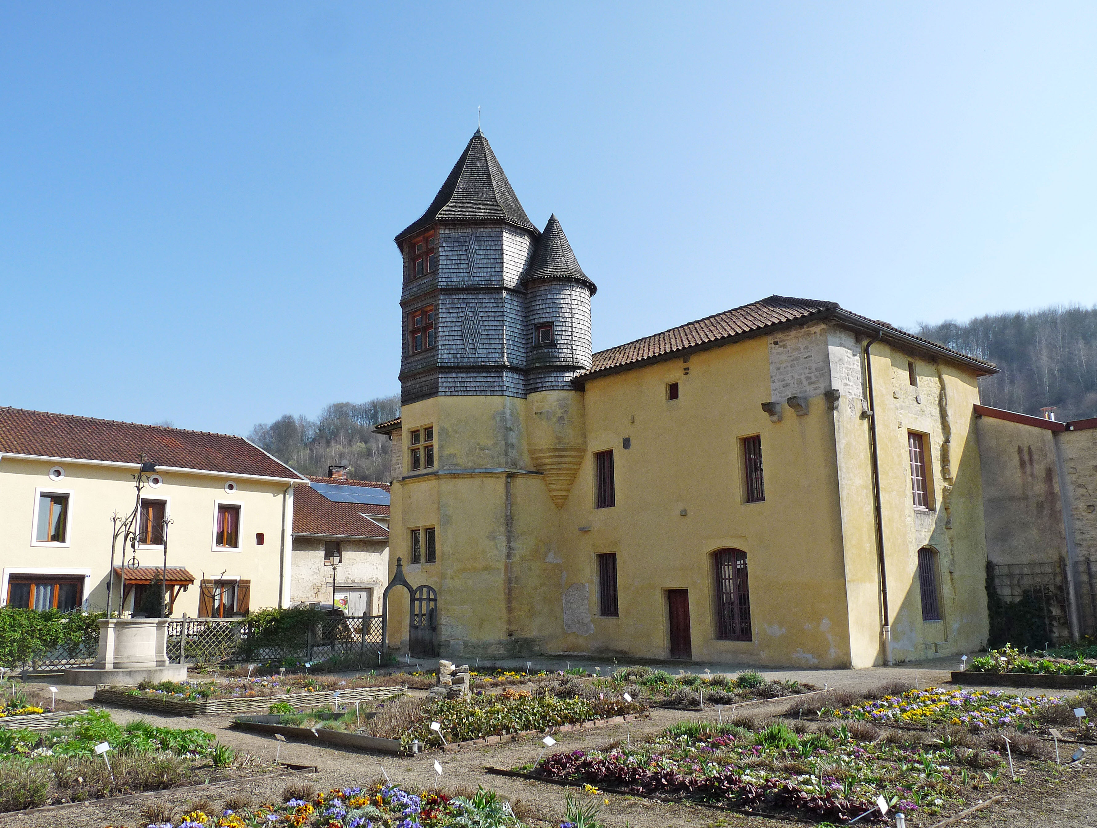
The next village is Chevillon, which is paired with Rachecourt-sur-Marne on the other side of the Marne. There is a canalside bar/restaurant here, the Inoubliable - what a great name! By now the landscape is beginning to change. There is more undulation, and there are more trees. The village has a couple of shops and a little station, but the biggest building in this part of the village is a wholesale cheese manufacturer, Les Fromagers de Chevillon, which has its own large shop. At the top of the hill is the oldest and most attractive part of the village. There you'll find the unusual yellow chateau, now a 'mediatheque' library, which is surrounded by a medieval garden.
Curel
Continuing south, still alongside the little railway line, the next village is Curel, just by Lock 48. It has a motorhome park by the canal. It is quite a nice old village, set on a hill, but it lacks a centre with heart. It has a boulangerie, but I haven't spotted a grocery shop.
Autigny-le-Grand
Further south, we pass the tiny village of Autigny-le-Grand. It's a sweet little place, but I don't believe that it has any shops or bars. We cruise past more countryside and through the Autigny-le-Grand Lock - number 47.
Joinville

We now reach the town of Joinville, which is surrounded by a cluster of hamlets: Bussy, Vecqueville, Thonnance les Joinville, La Madeleine, and Suzannecourt. The canal, the railway, and the River Marne converge here. Joinville had a population of 2,972 in 2021. It is a sprawling urban area, with a substantial rail terminal, and it does no appeal to me, although the town does have some pleasant older areas to the west, and some relaxing parkland. Sadly one of the main drawbacks is that there is little charm around the riverside and canalside. We exit the town at Lock 44, Joinville lock, and immediately enter delightful wooded countryside. We pass to the west of Saint-Urbain-Maconcourt, an unremarkable village, and continue south.
Rouvroy-sur-Marne
At Lock 41 an aquaduct carries the canal over the River Marne. The landscape is now more hilly and the canal winds arounf the countours. Just before Lock 40 we pass between Rouvroy-sur-Marne to the west, which has a small grocery, and Donjeux to the east. Neither of these have the heart which appeals to me.
Froncles
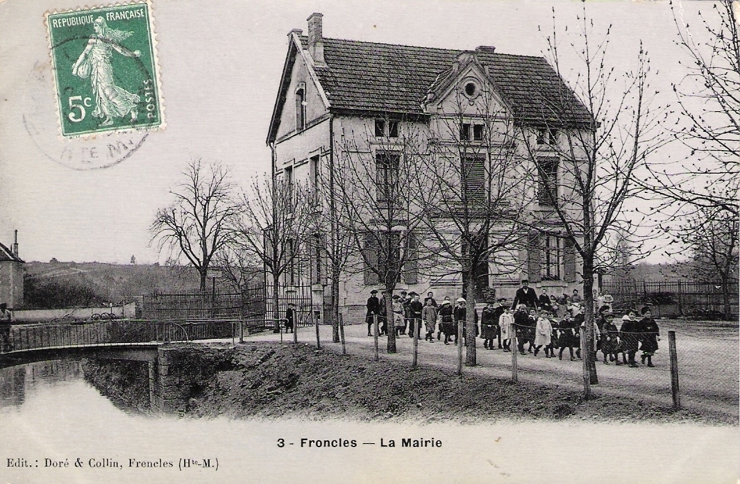
After a long cruise we reach Lock 36 and the village of Froncles, which had a population of 1,387 in 2021. The village is a sprawling working village, rather roady. It is a couple of nice looking streets, but lacks the old character I love. It has a Halte Nautique, a boulangerie, a small supermarket, and some other facilities.
Apparently, an experimental funicular transport track has recently been built in a warehouse in Froncles. This will be used to transport radioactive waste from the surface down to an underground nuclear waste management facility. If licensed, this new nuclear waste site, known as Cigeo, will be built somewhere along the border of the Meuse and Haute-Marne departments (not in Froncles, as far as I know). I don't much fancy living near that!
Vouécourt
The canal and the River wind on southwards, passing through the little village Vouécourt at Lock 34. There is nothing much here, but it's quite attractive, with a pretty church by the river, a smattering of older houses, a riverside campsite, and an unexpectedly large mairie. I'm not aware of any shops here.
Viéville
We end this post in the countryside at Viéville.